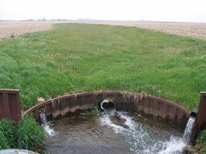
Advancing constructed wetlands and carbon bioreactors to abate edge-of field nitrogen losses
Estimating nitrate load reductions from placing constructed wetlands in a HUC-12 watershed using LiDAR data
Situation: To lessen hypoxia conditions (reduced dissolved oxygen) in the Gulf of Mexico nitrate-N losses from tile drainage throughout the Mississippi River Basin need to be decreased. Wetlands are one of the most effective practices to remove nitrate-N from drainage waters. When constructing wetlands, it is crucial that wetland location sites meet certain criteria, often on a watershed to watershed basis. LiDAR topographic data hold promise to identify feasible wetland sites remotely and estimate the impact constructed wetlands will have on watershed nitrate-N loads.
Actions: The study was conducted in Lime Creek, Illinois on a tributary that is within a 6500 ha watershed used dominantly for corn and soybean production. LiDAR data (topographic data obtained from a detailed altimetry survey conducted using aircraft) was used to identify suitable wetland sites using hydrologic routing analyses, and models were applied to estimate the effectiveness of nitrate removal in the wetlands based on nitrate loads.

Take-home message:
- Hydrologic analysis of topographic data sourced from a LiDAR survey was successful as a screening tool to identify suitable constructed wetland sites along with field verification.
- Models predicted that these potential wetlands could treat tile drainage from 30% of the watershed, resulting in an estimated 13% reduction nitrate-N from the watershed, a substantial reduction considering the application of one practice on a portion of the watershed.
- Installation of these sites would result in at most 6.2% of that part of the watershed serviced by the wetlands to be taken out of production.
- A large wetland could be constructed at the outlet of the watershed, and remove about a third of the total nitrate load from the watershed while taking less than 2% of its cropland out of production, however re-routing or raising of a local road would be involved with this option.
For more information:
- Tomer, M.D., W.G. Crumpton, R.L. Bingner, J.A. Kostel, and D.E. James. 2012-in press. Estimating nitrate load reductions from placing constructed wetlands in a HUC-12 watershed using LiDAR data, Ecological Engineering.
- Email Mark Tomer at mark.tomer@ars.usda.gov